Difference between revisions of "Place Gunung Batur"
From BASAbaliWiki
| Line 6: | Line 6: | ||
|Photograph=Gunung Batur.jpg | |Photograph=Gunung Batur.jpg | ||
|Information about place={{Place/Information | |Information about place={{Place/Information | ||
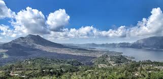
| + | |Description of information=Mount Batur (Gunung Batur) is an active volcano located at the center of two concentric calderas north west of Mount Agung on the island of Bali, Indonesia. The south east side of the larger 10×13 km caldera contains a caldera lake. The inner 7.5-kilometer-wide caldera, which was formed during emplacement of the Bali (or Ubud) ignimbrite, has been dated at about 23,670 and 28,500 years ago. | ||
| + | |||
| + | The first documented eruption was in 1804 and the most recent was in 2000. | ||
| + | |Link=https://peakvisor.com/peak/mount-batur.html | ||
|Video=https://www.youtube.com/watch?v=6gRPwIqJC_w | |Video=https://www.youtube.com/watch?v=6gRPwIqJC_w | ||
}}{{Place/Information | }}{{Place/Information | ||
| Line 14: | Line 18: | ||
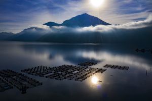
|Link=photo: Rio Helmi, https://riohelmi.com/ | |Link=photo: Rio Helmi, https://riohelmi.com/ | ||
}} | }} | ||
| − | |Topic=Kabupaten Bangli, | + | |Topic=Kabupaten Bangli, Natural Wonders |
| − | |SummaryTopic=located | + | |SummaryTopic=An active volcano located at the center of two calderas northwest of Mount Agung |
| − | |||
| − | |||
}} | }} | ||
Revision as of 04:35, 9 March 2022
- Name of Place
- Gunung Batur
- Location
- Reference
- Lontar
- Folktales
- Biographies
- Children's Books
- Books
- Holidays and Ceremonies
Information about place


Enable comment auto-refresher